Welcome (yes, it's me)

Welcome to the Blog of the Santa Clara County Surveyor being brought to you by Gwen Gee, PLS, CFedS.


We hope this will provide you updates and handy information about our office.


Sunday, October 30, 2016

Retired and Congratulation to Bill

As some of you may know, I'm now retired as Santa Clara County Surveyor.  The thrills of Santa Clara County Surveyor now belongs to Bill Slepnikoff who served as Deputy County Surveyor for several years.  Please give him a big hooray and wish him well. (I know he will do good)

Most of you may know that I only left the "day" job and now have time to focus on the things I enjoy doing like teaching, getting involved with new technology and doing activities that keep my mind sharp.  I do spend more time with my kitties who still dress up on Halloween.

So I will figure out how to update this Blog and find out how this can still be of some use rather then just me ranting on.

TTFN -
So perhaps now I will have more time to do this kind of stuff.

Gwen

Wednesday, July 22, 2015

Finally, take a look!

Well, coming back to posting now.  I hope my lapse will be worth taking a read at this post.

A picture aka image is always worth many words.  We have finally come up with a way to view maps from our Record Map Index.  They are know as "Counter Maps".  Counter Maps are what we use to index maps.

Go to this link
County Surveyor Counter Maps


Now enter a Book and Page for example Book 880 and Page 48

Now try Page 49


We will be adding more as time allows.
That's all folks.

A big thank you to my staff to made it all possible.


Monday, April 6, 2015

GIS Record Map Index (and CR index)

Happy April showers, may it help us with the drought.


Here a quick snip of the next "phase" of our indexes being converted into a GIS format.
I think a picture (or snippet) is worth lots of words.


Give the link below a try....

http://sccplanning.maps.arcgis.com/apps/webappviewer/index.html?id=bc21a949580746968cb7139386996978


Hopefully it will make you smile.
G

Wednesday, February 11, 2015

Corner Record searching on GIS

Oh how time flies!  I'm back to posting again.  And I've got something to share!

Here's a new handy tool to use for searching for Corner Records in Santa Clara County.
First, here's a glimpse...


As you can see, the County GIS is the background.  The purple squares represent Corner Records that have been filed.  Once you zoom in close enough, a pop-up will allow you to "Click for Corner Record" for viewing the actual Corner Record. 

If you zoom out to this view, you can pan around to an area of interest.  If see this pop-up, you can "Click for Cadastral Map Image" and voila, a Cadastral Map will appear.  Even though these are dated, they are good for finding older recorded maps and vault maps.  For the old-timers, you know what I mean.


So if you like this preview, then keep an eye on our website for this new feature.

www.sccgov.org/sccsurveyor


...until next time have a good time.


Gwen


Tuesday, June 17, 2014

Time flies....

Yes, I have missed posting for a few months, broke my goal of posting once a month.  Which means I owe a nice long post or a few quick posts to catch up.  From my previous post, it will be hard to top that off!

The economy seems to have recovered.  We are busy in the County Surveyor's Office.   I hear of people getting hired in surveying positions.  I got some calls from land surveyors looking for people to hire.  So it is a very active time.  A great welcome to our profession.

Sometimes it's just being in the right place at the right time.  The decisions we made in the past puts us in positions for opportunities when they knock on our door.

So here's a small world story.  A long time ago I worked a summer job at Inyo National Forest on a survey crew.   We were a mighty 6 person crew, a few from colleges, a couple making job transitions and my boss.
Making a long story short and sweet, that was a great job.  It was my very first surveying job and I learned so much.  Well, a couple of decades later, 33 years if you want numbers, I meet up with this guy Doug.  After a few questions to jog the memory I shout "Cowboy Doug?"  Yup, he and worked on this one survey crew, one summer 33 years ago.  Wow!  And to top that off, he is now County Surveyor for San Luis Obispo.  Now you math gurus, what is the chance that TWO people from this summer survey crew would BOTH end up as County Surveyors.

Amazing!  Now I really believe in that 7-degrees of freedom theory (aka the Kevin Bacon theory)


Friday, March 14, 2014

Valley Of the Hearts Delight

Ah, yes, finally a time to pause and get back to this Blog.  It's good to see things get busy in the area.  As we see things change from the past, say 50+ years ago, when we get a moment to ponder.  We think about what this valley looked like years ago.  I get to ponder quite a bit as I am force to slow my pace down as I commute in traffic.  Well that's the plus side of a slow commute.  Our ISD - Information Services Department put together an online historical map.  A big thanks goes to Doug S. who has been a great help and inspiration to us in expanding more into the GIS world.  (GIS = Geographical Information System)
And a big thanks to Brad B., PLS who stitched the map together and shared it with us.

Here's a preview to get you interested.

First we have the big screen picture....a couple of views....


Now zoom with the "circle" or "loupe" aka magnifier....


Zoom in closer and see....


So what you are seeing in the background is the County GIS layer so you can relate to what it looks like today.

To see what potential this has, zoom to Mt View and you will see....


now you say, what the....is that?  It's an old map of Mt View that you can view along with the background.

So check it out the webmap, play around with it and  have some fun.

Here's the link:

http://bit.ly/valleyofheartsdelight

And remember to have some pie today for it's Pi day!


Monday, December 30, 2013

Thanks for 2013

Just a moment to say "thanks" to all who have gave us support throughout the year.  You gave us patience when we are short staffed, constructive comments when we are looking to improve, humor to keep our chins up, and most of all, your professionalism.  I would like to thank my staff for their patience and motivation to do a "good" job.  Even though we all work for that paycheck, what brings us to a higher level is that we like what we do and that is land surveying.  There are so many careers to choose from and many which make a lot more money, yet some of the most dedicated people are those in land surveying.  Perhaps it is a calling to us that complements our own persona.  Like a favorite pair of jeans, an old T-shirt we always wear, it just feels right and good at the same time.

I would also like to thank the many people who have been a part of my surveying career.  Recently, I received CEAC - County Engineers Association of California award for County Surveyor of the Year.  This is a great honor and quite a pleasant surprise.  This would not have been possible without the dedicated staff who work in the County Surveyor's Office here.  They have taken on various "hats" and used their hidden talents to help make this Office better, for the public at large and for the internal and external customers alike.
All while facing the difficulties and challenges of working in a governmental institution.  So I share this honor with my dedicated County Surveyor staff.

It takes a special kind of person to perform public service and truly be effective, and at the same time content to work in such an environment.

"Success is no accident.  It is hard work, perseverance, learning, studying, sacrifice and most of all, love of what you are doing." - Pete

Happy New Year 2014 to you all.
   - Gwen

Monday, September 30, 2013

Researching at the County Surveyor's Office

Well I fell off the blogging for a bit.  Did a bit of traveling through the states, saw great views, got some rain (monsoon season in the US?) experienced desert heat, gusty winds and spend a lot of money buying gas.

Every good survey starts with a good amount of time doing research.  Especially for a boundary survey.  The kind we lose sleep at night pondering whether we looked and evaluated every corner, monument, tree, lines of occupations, etc. before we place our precious LS stamp on the map.  And it's done....at least we think so.  Then we suddenly awake from a nightmare when we hear the words "did you find this corner right here?"

The importance of researching a piece of property can never be underestimated.  In the 58 Counties in California, it seems like there are 58+ ways to do research.  The California Land Surveyor Association (CLSA) has a publication, the award winning California Surveyor.   In the current issue, several Counties have an article on how to perform researching at the County Surveyor's Office.  There are several articles on the importance of researching especially in dealing with land boundaries.  And sometimes the saying goes, finding a map with the monuments on it is "priceless".  And not finding the map with the monuments you are using "costly".

So check our the latest issue of CLSA's California Surveyor.

http://www.californiasurveyors.org/index.asp

And a great photo is on the cover too!  (nice pic Steve!)


Being a Californian, I guess next time I'll do more research on the weather in other states!

Friday, June 28, 2013

End of Fiscal Year 2012-2013

Well another fiscal year ends.  What's that?  It's like the typical calendar year that goes from January to December.  We look forward to certain times of the year like April for taxes, December for shopping, June through August for summer vacations.  In our government sense, it goes from July 1st to June 30th.  So the things we look forward to are mid-year budget adjustment, fee changes, County ordinances changes, budgets of departments "finalizes", County budget approved, etc....I think you get the drift.  Also, many County and City officials take a "break" in July, some don't have regular meetings in July.  Being a cross-over from private business to public service, these differences are not obvious until you live through them a few times.  So sometimes you may wonder, are they really that busy over there?  While there are many things that go on "behind the scenes" in government, I have learned to address questions that are unique to this situation.

But all this being said, my staff appreciates the patience you have given us in trying to provide good customer service.  I call us the Four Musketeers.  I'll let your imagination fill in the rest.

Gwen

Enjoy the start of summer!  The heat is definitely here!


Monday, May 6, 2013

County Surveyor Indexes now available ONLINE NOW!

Yes, you have read that right!  We have put the County Surveyor Indexes online.

So what does that mean?  It means you can do some map researching online on our website.  This is a start in a long awaited request from just about everybody I've talked to about doing map research here.

This is our very first launch on such so over time, it will improve.  Let's consider this our "beta" version.  Great cudo's my staff for making such a great effort.  The only thing we will miss is the friendly phone calls from our customers.

Ok, here's the snapshots to get you interested...

You must use Microsoft Internet Explorer or Mozilla Firefox as your browser for now.

First find The Santa Clara County - County Surveyor's website.
You can try one of the links for the County Surveyor's Website below:

Office of the County Surveyor

or

http://www.sccgov.org/sites/dso/County%20Surveyor/Pages/Map-Research-Procedures.aspx

You will hopefully see this page:


Next, go to the County Surveyor - Record Indexes
(yes you will need to accept the disclaimer to continue)


So far so good, right?  Go ahead and you should now be at this page:


Yes, now this IS a new page that we just added.  A very talented person created this.


(very cool isn't it?)


So now let's cruise the links....


Let's take a look at the Map Research link.

We have the basics on map researching.
There is a step-by-step on how to determine the County Grid Number.

This is the same County Grid Number that we've used for a long, long time and it IS still the way we do indexing for now.

Of course, for the advanced user, you can just check out all the links and see what they do.


There are other links for:

  • Cadastral Maps
  • Record Map Index
  • Corner Record Index
  • Tract Number to Map Index


Some of the links take little time to load.
(if you cannot get the indexes to load, check to see if you are using MS Internet Explorer or Firefox)

Some highlights:
   - you can search and view the Corner Records
   - you can obtain the Book and Page of a map from the Tract number or name
   - you can determine the County Grid Number from our Cadastral Maps

Yes, the Cadastral Maps have not been updated since about 1989 due to the mapping program being discontinued.  Someday we hope to integrate the County GIS, but that is another item on our list.

And I bet this is something  you've been waiting to see:


So check it out.  We know there is room for enhancements.  Send us feedback, let us know how you like it.

Thanks!
Gwen


Friday, April 12, 2013

New Deputy County Surveyor

Yes, you are reading that correctly.  We have a new addition to our small and mighty staff.

Please welcome Bill Slepnikoff, PLS as our new Deputy County Surveyor.  Some of you may know him as a familiar face.  He has connections with many people in the land surveying community.  You may have seen him at the CLSA (California Land Surveyors Association) or at some other survey related function, or perhaps you may have worked with him on a project or two.  As we orient him into the County government environment, please be patient, it takes a bit to know how things work (or don't work) around here.  I apologize for not announcing it sooner (He started just after Thanksgiving!), things got a bit hectic here with the computer changeover and network challenges.  And of course the holidays came and went as some of you may have experienced.  Well he has made it through the first 90 days (sound familiar?) and so far we haven't scared him off.


Here's a pic so you can recognize him next time you come by our office.


Bill Slepnikoff, PLS
Deputy County Surveyor
   
Office of the County Surveyor
70 West Hedding St
East Wing, 7th floor
San Jose, CA  95110
Bus: (408) 299-6862
Bus Fax: (408) 275-6412


And he and Chris made photo of the month for our CLSA East Bay Chapter newsletter.
Way to go guys! X marks the spot all right!


Thank you Bill for joining the County Surveyor's staff.

Gwen

Monday, March 11, 2013

BTW - And thanks to our ISD department for making this topo layer (and more) available.

For information on what you will need in order to view it, see below.  I know some of you have already figured it out, that's ok, we know who you are.


Map.aspxhttp://www.sccgov.org/sites/gis/Santa%20Clara%20County%20Interactive%20Map/Pages/Santa-Clara-County-Interactive-Map.aspx


County GIS now has topo layer

OMG another blog....ok I'm making up for not blogging awhile back....

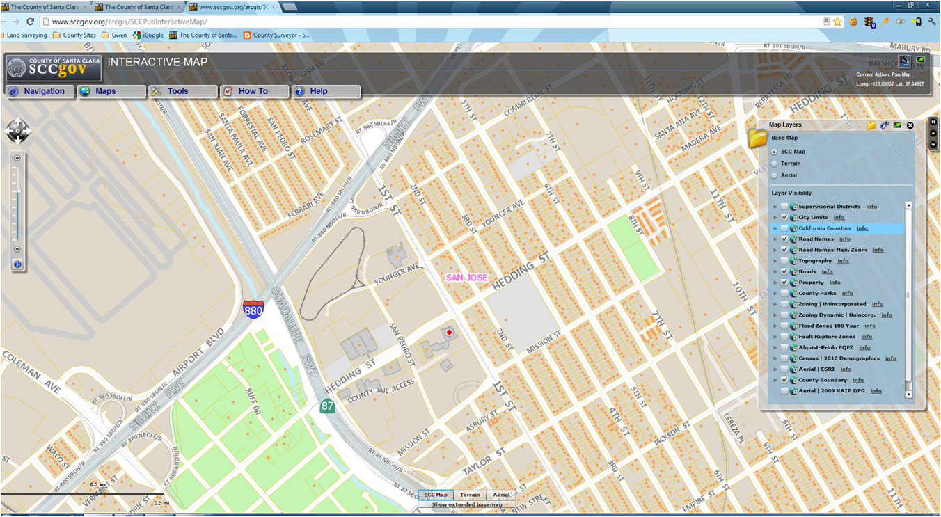
Yes, now you can go to our County GIS and see the topo layer.  Happy?  I bet a lot of people will spend time zooming around this layer and checking it out.

A little refresher on how to get to this site:

Go to:
 
http://www.sccgov.org/arcgis/SCCPubInteractiveMap/

(yes you will get to read the "Welcome" etc.  Close it to continue. )


so good so far?
Now go to the "Maps" tab and click the "Map Layers".  Look for the "Topography" layer and check the box.


Hopefully you will be contour lines.  So enjoy this little tidbit!


Friday, March 1, 2013

National Surveyors Week

Yes, we have a week of recognition!  It's National Surveyors Week!  Yes it does exist and actually has been for several years now.  San Jose City Surveyor Patty Cannon, PE, PLS and I were presented with a proclamation from the City of San Jose to proclaim National Surveyors Week in 2010.  In 1986, the County   Board of Supervisors had a proclamation for Surveyors Week also.  This year, National Surveyors Week is set for March 17-23, 2013.

The National Society of Professional Surveyors (NSPS) has requested "The President" to design this week as "
National Surveyors Week".  Ok, I think you get the theme of this now.

So a few excerpts from the Executive Director of NSPS...just in case the print is a tad small to read...and some big points to make...


"...Former surveyors include George Washington, Thomas Jefferson, and Abraham Lincoln..."

Thomas Jefferson is credited with creation of the Public Land Survey System ("PLSS"), the rectangular system that continues today in 30 states which includes California.  Well that hits home a bit.

And, as NPSP points out, there are over 45,000 professional surveyors in the US.  In California, I recall someone saying there are about 4,000 licensed land surveyors.  What is scary is that compared to the population of California, it's a very small percentage.  So we land surveyors are becoming a rare profession. Hopefully not an extinct profession yet but not very common let's just say.  Awhile back we had a display of land surveying items, courtesy of the Mt Diablo Surveyors Historical Society.  (thanks Don!)

So, we are recognized in history.  So I encourage you  to go out and celebrate!

G


Friday, November 30, 2012

How Do You Find A Surveyor?

I wish I had a dollar for every time I was asked that question here.  Once upon a time, we would reply "Look in the yellow pages" but that response is somewhat dated nowadays.  We could say look online or Google is (which is one of my favorite phases).  Now we refer them to the California Land Surveyors Association website commonly know as CLSA.  You can search by zip code, by area of practice or by name.  The list is comprise of CLSA licensed members in private land surveying business.  The list will also indicate if they participate in the Professional Development Program.  This is currently a voluntary program but may become mandatory sometime in the future.  For us CLSA members that are in the public sector, our names would not be on this list but it is a great way to keep track of the seminars and workshops attended.  That's great that CLSA will keep this on record for us members.  One less thing for me to track!  Like it.

Here is CLSA's website:
http://www.californiasurveyors.org/index.asp

And a preview of the site:


On the right under "Member Login" you can click the Find A Surveyor to start a search. 
Fill out the form (of course)


And there you have it!

We are thankful for CLSA for providing this.

Thursday, October 4, 2012

Cadastral Maps and County Grid Numbers

The County Cadastral maps will be on the County Surveyor's Website this month, probably about mid-month if all goes well.  These are digital files that you can open and save for your use.  The information on these maps were last updated about 1986-88.  At that time the County Surveyor's mapping program was discontinued by the County and the maps were left untouched.  So these are the mylar maps that were scanned into TIFF and PDF files.  The maps were on 26" x 36" mylars, made from the historical process of using overlays, Leroy lettering and hand drafted with inking pens such as  Rotring and by Koh-i-Noor. (historical drafting that predated CAD)  They are useful for determining the County Grid Number which is used for geographically indexing maps.  Our Planning and Land Development-Engineering (LDE) uses the County Grid Number in their files also.  So this is useful in doing research.

Here's some general information.


County Cadastral Map


Generally, cadastral maps are use to portray boundaries of tracts and subdivisions of lands within the County of Santa Clara.

A cadastral map is a map showing the boundaries of subdivisions of land.  It is based on bearings, lengths and areas of individual tracts, for purposes of describing and recording ownership.  Some areas on the cadastral map may also show topography, drainage, and other features relating to the value of the land and its uses.  The cadastral map number is the first number used in the series of three numbers for determining the County Grid Number.  For example: County Grid No. 67-37-70 where 67 is the Cadastral Map number.  See below for the rest of the County Grid Number. 

The Cadastral Map layer is comprised of the County Cadastral Maps series that cover the entire County of Santa Clara.  It contains 281 individual maps and numbered from west to east and from north to south.  Cadastral Map No. 1 is in the northwest area of Santa Clara County.

Each cadastral map covers approximately 150,000,000 ft sq..

County Grid Number (XY Grid Index)

Sometimes referred to as the xy grid, grid index, Santa Clara County Grid, County Grid Number.

Santa Clara County Coordinate System is a grid system comprised of x coordinates that run west to east and y coordinates that run south to north numerically. 

Each County Cadastral map has a grid as follows:

6 grids east and west (X-axis) that covers approximately 15,000 feet 
4 grids north and south (Y-axis) that covers approximately 10,000 feet 

They are based on California Coordinate System (CCS) but I'll go into that on another Blog....

Here's a sample of a Cadastral Map No. 67
From the example above, for our office which is located in County Grid No. 67-37-70 means Cadastral map number, 37 is the x-value and 70 is the y-value.


Thursday, September 6, 2012

GIS Quick Link - County Surveyor Website

Yeah!

We have added a Quick Link to our website that will take you directly to our County GIS website.


Easy steps to follow:

 1- go to the County Surveyor website


www.sccgov.org/sccsurveyor/

 2- look on the right hand side for Quick Link


 3- double click on the last item " Santa Clara County GIS"

You can navigate around and see the tools and views.

Here's a couple of screen shots to get you interested.


Soon you will see additional layers such as the County Cadastral Maps.  So why is that significant?  Right now, this is how you can determine the County Grid Number for an area.  And with that, you can use it and the Excel spreadsheets (Record Maps and Corner Records) to find maps and Corner Records in your area of interest.

Now for the real good news, we are developing a GIS layer so you can search for record maps and Corner Records.

TTFN - stayed tuned!

Thanks for all you patience.

Please post a comment and let us know how we are doing.

Gwen

Thursday, August 16, 2012

Lower fee for Record of Survey maps

Yes, you read that right.  Starting August 21, 2012, the map check fee for Record of Survey maps has been reduced from $600 to $586 and will become billable.  Billable means that:

"When staff time exceeds the amount paid ($586 fee), the owner/applicant will be required to pay additional fees to cover the cost of staff time to complete the service."

Also, the Surveyor's hourly billable rate for  for FY 2012 was reduced from $164 to $133 per hour.

For the complete list of fees for our department see Board Resolution 2012-371.
For the hearing see Board Of Supervisors Full Agenda date June 19, 2012 (page 153 of 3416)

Hope that is some good news for FY2013.

We look forward to seeing your R/S maps.

Tuesday, August 7, 2012

Monument Preservation

FYI
For monumentation preservation issues:

(i.e. monuments being paved over or destroyed by municipal project, contractors, etc.)

Contact:

Larry Kereszt
Larry.kereszt@dca.ca.gov
916-263-2240

Board for Professional Engineers, Land Surveyors, and Geologists (BPELSG)
Department of Consumer Affairs
Sacramento, CA

Tuesday, July 17, 2012

Benchmarks aka Vertical Control by SCVWD

Santa Clara Valley Water District (SCVWD) has done a great job in revamping their website for benchmarks, aka vertical control.  Check it out.  It is really cool.
Good cudo's to our fellow land surveyors at SCVWD !!!

http://arcview.valleywater.org/benchmarks/mobile.html


Gwen