OMG another blog....ok I'm making up for not blogging awhile back....
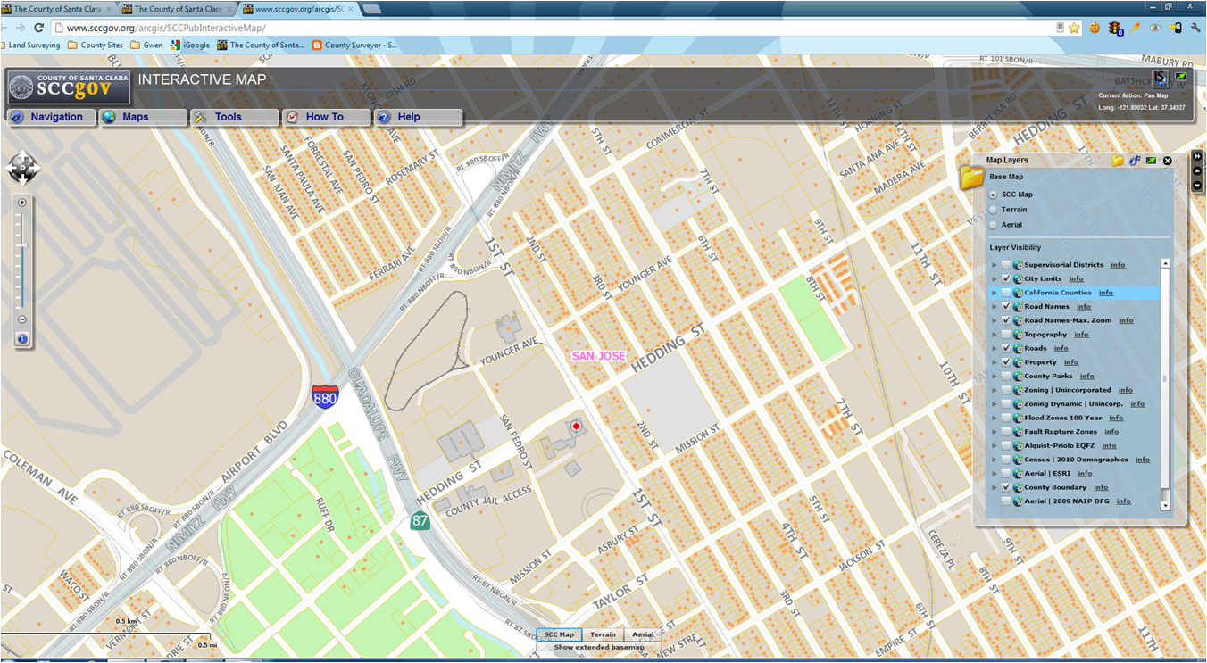
Yes, now you can go to our County GIS and see the topo layer. Happy? I bet a lot of people will spend time zooming around this layer and checking it out.
A little refresher on how to get to this site:
Go to:
http://www.sccgov.org/arcgis/SCCPubInteractiveMap/
(yes you will get to read the "Welcome" etc. Close it to continue. )
so good so far?
Now go to the "Maps" tab and click the "Map Layers". Look for the "Topography" layer and check the box.
Hopefully you will be contour lines. So enjoy this little tidbit!
County Surveyor's blog Office Of The County Surveyor County of Santa Clara, California
Welcome (yes, it's me)
Welcome to the Blog of the Santa Clara County Surveyor being brought to you by Gwen Gee, PLS, CFedS.
We hope this will provide you updates and handy information about our office.
Monday, March 11, 2013
Friday, March 1, 2013
National Surveyors Week
Yes, we have a week of recognition! It's National Surveyors Week! Yes it does exist and actually has been for several years now. San Jose City Surveyor Patty Cannon, PE, PLS and I were presented with a proclamation from the City of San Jose to proclaim National Surveyors Week in 2010. In 1986, the County Board of Supervisors had a proclamation for Surveyors Week also. This year, National Surveyors Week is set for March 17-23, 2013.
The National Society of Professional Surveyors (NSPS) has requested "The President" to design this week as "
National Surveyors Week". Ok, I think you get the theme of this now.
So a few excerpts from the Executive Director of NSPS...just in case the print is a tad small to read...and some big points to make...
"...Former surveyors include George Washington, Thomas Jefferson, and Abraham Lincoln..."
Thomas Jefferson is credited with creation of the Public Land Survey System ("PLSS"), the rectangular system that continues today in 30 states which includes California. Well that hits home a bit.
And, as NPSP points out, there are over 45,000 professional surveyors in the US. In California, I recall someone saying there are about 4,000 licensed land surveyors. What is scary is that compared to the population of California, it's a very small percentage. So we land surveyors are becoming a rare profession. Hopefully not an extinct profession yet but not very common let's just say. Awhile back we had a display of land surveying items, courtesy of the Mt Diablo Surveyors Historical Society. (thanks Don!)
So, we are recognized in history. So I encourage you to go out and celebrate!
G
The National Society of Professional Surveyors (NSPS) has requested "The President" to design this week as "
National Surveyors Week". Ok, I think you get the theme of this now.
So a few excerpts from the Executive Director of NSPS...just in case the print is a tad small to read...and some big points to make...
"...Former surveyors include George Washington, Thomas Jefferson, and Abraham Lincoln..."
Thomas Jefferson is credited with creation of the Public Land Survey System ("PLSS"), the rectangular system that continues today in 30 states which includes California. Well that hits home a bit.
And, as NPSP points out, there are over 45,000 professional surveyors in the US. In California, I recall someone saying there are about 4,000 licensed land surveyors. What is scary is that compared to the population of California, it's a very small percentage. So we land surveyors are becoming a rare profession. Hopefully not an extinct profession yet but not very common let's just say. Awhile back we had a display of land surveying items, courtesy of the Mt Diablo Surveyors Historical Society. (thanks Don!)
So, we are recognized in history. So I encourage you to go out and celebrate!
G
Friday, November 30, 2012
How Do You Find A Surveyor?
I wish I had a dollar for every time I was asked that question here. Once upon a time, we would reply "Look in the yellow pages" but that response is somewhat dated nowadays. We could say look online or Google is (which is one of my favorite phases). Now we refer them to the California Land Surveyors Association website commonly know as CLSA. You can search by zip code, by area of practice or by name. The list is comprise of CLSA licensed members in private land surveying business. The list will also indicate if they participate in the Professional Development Program. This is currently a voluntary program but may become mandatory sometime in the future. For us CLSA members that are in the public sector, our names would not be on this list but it is a great way to keep track of the seminars and workshops attended. That's great that CLSA will keep this on record for us members. One less thing for me to track! Like it.
Here is CLSA's website:
http://www.californiasurveyors.org/index.asp
And a preview of the site:
On the right under "Member Login" you can click the Find A Surveyor to start a search.
Here is CLSA's website:
http://www.californiasurveyors.org/index.asp
And a preview of the site:
On the right under "Member Login" you can click the Find A Surveyor to start a search.
Fill out the form (of course)
And there you have it!
We are thankful for CLSA for providing this.
Thursday, October 4, 2012
Cadastral Maps and County Grid Numbers
The County Cadastral maps will be on the County Surveyor's Website this month, probably about mid-month if all goes well. These are digital files that you can open and save for your use. The information on these maps were last updated about 1986-88. At that time the County Surveyor's mapping program was discontinued by the County and the maps were left untouched. So these are the mylar maps that were scanned into TIFF and PDF files. The maps were on 26" x 36" mylars, made from the historical process of using overlays, Leroy lettering and hand drafted with inking pens such as Rotring and by Koh-i-Noor. (historical drafting that predated CAD) They are useful for determining the County Grid Number which is used for geographically indexing maps. Our Planning and Land Development-Engineering (LDE) uses the County Grid Number in their files also. So this is useful in doing research.
Here's some general information.
They are based on California Coordinate System (CCS) but I'll go into that on another Blog....
Here's a sample of a Cadastral Map No. 67
From the example above, for our office which is located in County Grid No. 67-37-70 means Cadastral map number, 37 is the x-value and 70 is the y-value.
Here's some general information.
County Cadastral Map
Generally, cadastral maps are use to
portray boundaries of tracts and subdivisions of lands within the County of
Santa Clara.
A
cadastral map is a map showing the boundaries of subdivisions of land. It is based on bearings, lengths and areas of
individual tracts, for purposes of describing and recording ownership. Some areas on the cadastral map may also show
topography, drainage, and other features relating to the value of the land and
its uses. The cadastral map number is
the first number used in the series of three numbers for determining the County
Grid Number. For example: County Grid No. 67-37-70 where 67 is the Cadastral Map number. See below for the rest of the County Grid Number.
The Cadastral Map layer is comprised of the County Cadastral
Maps series that cover the entire County of Santa Clara. It contains 281 individual maps and numbered
from west to east and from north to south.
Cadastral Map No. 1 is in the northwest area of Santa Clara County.
Each cadastral map covers approximately 150,000,000 ft sq..
County Grid Number (XY Grid Index)
Sometimes referred to as the xy
grid, grid index, Santa Clara County Grid, County Grid Number.
Santa
Clara County Coordinate System is a grid system comprised of x coordinates that
run west to east and y coordinates that run south to north numerically.
Each County Cadastral map has a grid as follows:
6 grids east and west (X-axis) that covers approximately 15,000 feet
4 grids north and south (Y-axis) that covers approximately 10,000 feet
They are based on California Coordinate System (CCS) but I'll go into that on another Blog....
Here's a sample of a Cadastral Map No. 67
From the example above, for our office which is located in County Grid No. 67-37-70 means Cadastral map number, 37 is the x-value and 70 is the y-value.
Thursday, September 6, 2012
GIS Quick Link - County Surveyor Website
Yeah!
We have added a Quick Link to our website that will take you directly to our County GIS website.
Easy steps to follow:
1- go to the County Surveyor website
www.sccgov.org/sccsurveyor/
2- look on the right hand side for Quick Link
3- double click on the last item " Santa Clara County GIS"
You can navigate around and see the tools and views.
Here's a couple of screen shots to get you interested.
Soon you will see additional layers such as the County Cadastral Maps. So why is that significant? Right now, this is how you can determine the County Grid Number for an area. And with that, you can use it and the Excel spreadsheets (Record Maps and Corner Records) to find maps and Corner Records in your area of interest.
Now for the real good news, we are developing a GIS layer so you can search for record maps and Corner Records.
TTFN - stayed tuned!
Thanks for all you patience.
Please post a comment and let us know how we are doing.
Gwen
We have added a Quick Link to our website that will take you directly to our County GIS website.
Easy steps to follow:
1- go to the County Surveyor website
www.sccgov.org/sccsurveyor/
2- look on the right hand side for Quick Link
3- double click on the last item " Santa Clara County GIS"
You can navigate around and see the tools and views.
Here's a couple of screen shots to get you interested.
Soon you will see additional layers such as the County Cadastral Maps. So why is that significant? Right now, this is how you can determine the County Grid Number for an area. And with that, you can use it and the Excel spreadsheets (Record Maps and Corner Records) to find maps and Corner Records in your area of interest.
Now for the real good news, we are developing a GIS layer so you can search for record maps and Corner Records.
TTFN - stayed tuned!
Thanks for all you patience.
Please post a comment and let us know how we are doing.
Gwen
Thursday, August 16, 2012
Lower fee for Record of Survey maps
Yes, you read that right. Starting August 21, 2012, the map check fee for Record of Survey maps has been reduced from $600 to $586 and will become billable. Billable means that:
"When staff time exceeds the amount paid ($586 fee), the owner/applicant will be required to pay additional fees to cover the cost of staff time to complete the service."
Also, the Surveyor's hourly billable rate for for FY 2012 was reduced from $164 to $133 per hour.
For the complete list of fees for our department see Board Resolution 2012-371.
For the hearing see Board Of Supervisors Full Agenda date June 19, 2012 (page 153 of 3416)
Hope that is some good news for FY2013.
We look forward to seeing your R/S maps.
"When staff time exceeds the amount paid ($586 fee), the owner/applicant will be required to pay additional fees to cover the cost of staff time to complete the service."
Also, the Surveyor's hourly billable rate for for FY 2012 was reduced from $164 to $133 per hour.
For the complete list of fees for our department see Board Resolution 2012-371.
For the hearing see Board Of Supervisors Full Agenda date June 19, 2012 (page 153 of 3416)
Hope that is some good news for FY2013.
We look forward to seeing your R/S maps.
Tuesday, August 7, 2012
Monument Preservation
FYI
For monumentation
preservation issues:
(i.e. monuments being paved
over or destroyed by municipal project, contractors, etc.)
Contact:
Larry Kereszt
Larry.kereszt@dca.ca.gov
916-263-2240
Board for Professional
Engineers, Land Surveyors, and Geologists (BPELSG)
Department of Consumer
Affairs
Sacramento, CA
Subscribe to:
Posts (Atom)